Here is the Bremen plot of AMSR-2 sea ice concentration from my previous post, the region at issue is the darkening in the upper left quadrant.

Now four days on the feature is persisting and likely expanding.

So what of Chukchi?

Chukchi extent is collapsing well ahead of any other year.

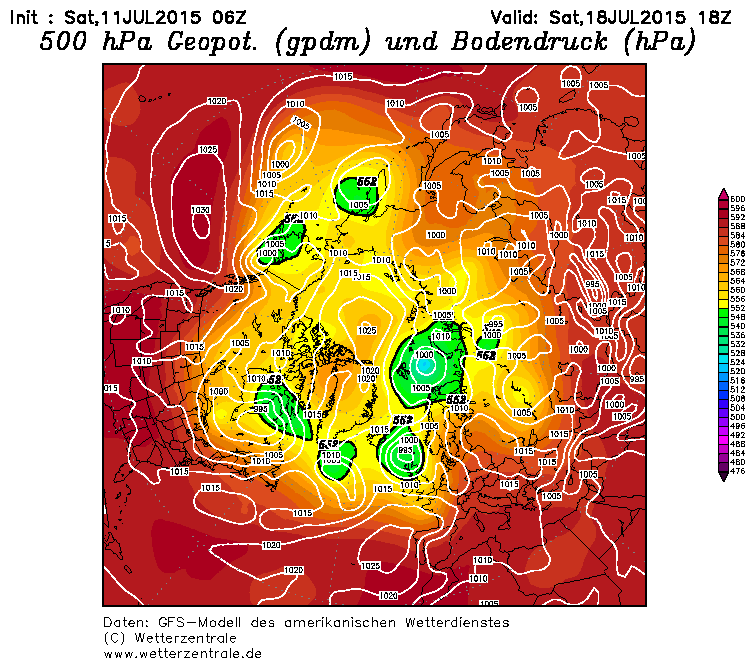
Chukchi compactness is below any other year. It looks likely that Chukchi will be wholly ice free before the end of July. This is especially as the Arctic remains dominated by high pressure for the next 7 days in forecast models like GFS. Images from Wetterzentrale.
Current

18 July Forecast.


And Beaufort Sea extent fails to decline.

This looks to me to be a result of the presence of multi year ice, as shown in the following graphic from Fowler/Maslanik/Tschudi's drift age model.

So it is still feasible that, like Beaufort, the presence of MYI in the Chukchi Sea could cause loss rates to slow later in July.
PS, for comparison, here is the 2012 ice age distribution from the drift age model. The point being the greater spread of MYI in 2015.

22 comments:
Well, aside from the fact that it draws a very interesting creature, that map also shows how potentially vulnerable all that very thick ice is, strung out into a long strand and virtually unprotected by slightly younger ice, in contrast to previous years. Add the usual caveat that weather is all, but it seems that the ice grows more fragile year by year, and all it will take to smash the historical records is one major weather event.
Notjonathon. Perhaps you're right, but remember that the ice is sometimes more resilient than we give it credit for. I'm a little bit more reserved about it myself.
Others are more qualified than I, but I'm intrigued by the pointillist nature of the thickest ice, unless this is an artifact (American spelling) of the algorithm being used. In addition, it seems unlikely that any five-meter ice halfway down the Greenland coast is going to survive.
And I still see a giant rat.
Notjonathan,
Are you talking about the drift age model (I just have added 2012 for the same week).
The drift age model uses weather data of winds to model the movement of ice, the ice is in packets which the wind moves around. If a packet survives the summer melt its age is increased by one year. Any packet's age is the age of the oldest ice covering over 15% of the packet's area. So where old ice gets dispersed it gets very pointillist as you observe.
Thanks for the further explication. So 2012 was more like a lobster.
I'm quite curious to see what becomes of the MYI shown in the drift age model. Eyeballing Climate Reanalyzer, conditions over the coming week will give Chukchi something of a respite. But winds push the MYI toward the west and south, where it will be subjected to warmer water as well as above-normal air temps (especially in eastern Beaufort and southern ESS.) Will it be mostly gone by September, or will the gyre replenish it?
Notjonathon,
It's definitely vulnerable, so it's interesting to see how it all shakes out.
EDIT: I guess not much MYI will reach the southern ESS, so it's more a matter of how soon the FYI there melts and exposes the thicker ice to direct melting from water and wave action.
It seems like the extremist patrol has taken over the comments on Neven's ice thickness comments, questioning the accuracy of Piomas and saying the ice will go poof this year or next. I have to laugh at that. They're so obviously wrong
Chris, you say: "It looks likely that by September Chukchi will be wholly ice free before the end of July." Do you mean "It looks likely that by September Chukchi will be wholly ice free"?
...Or do you mean "It looks likely that the Chukchi will be wholly ice free before the end of July"?
Nicky,
Thanks for catching that (I also had a duplicate graph!), the dangers of late night posting. I've now tidied it up. And yes, in my opinion, by the end of this month it is likely that Chukchi will be ice free.
Dreesen,
Yes it is rather tiresome. When the evidence doesn't go along with people's pre-suppositions, they question the evidence, and cast about for evidence that does support them.
Just three days away due to work, and things are looking really exciting.
Chris, thanks for the reply. July will definitely see big drop, but am I correct in thinking September probably won't come close to 2012? Anyway, thanks for standing up for me on the Neven blog. It gets frustrated dealing with the radical crowd. I also noticed George was saying the Navy model predicted a cliff dive on the ice in the next week or so. Your thoughts?
Leaving aside the models, and looking at AMSR2 from Bremen, the pack is darkening markedly indicating lower concentration. Everything I'm seeing through to 22 June on GFS suggests to me that the summer AO pattern that dominated summers from 2007 to 2010 is back. I expect above average losses from now until later in August from Chukchi through to Laptev, at least until such seas become virtually ice free.
2007 and 2011 are easily attainable if current weather persists, and I would not rule out a minimum near 2012. What argues for a low probability of a 2012 type minimum is the drift age model(DAM).
ftp://ccar.colorado.edu/pub/tschudi/iceage/gifs/
Compare week 27 of this year with week 27 of 2012, this year has a lot more multi year (MYI) ice in the way. Weather might beat that, but it might not.
Leaving the DAM aside, as a model, consider ASCAT.
http://manati.star.nesdis.noaa.gov/ascat_images/ice_image/2012/
That's basically a radar, MYI shows as brighter white. Here is day 100 of 2012
http://manati.star.nesdis.noaa.gov/ascat_images/ice_image/2012/msfa-NHe-a-2012100.sir.gif
And day 100 of 2015.
http://manati.star.nesdis.noaa.gov/ascat_images/ice_image/msfa-NHe-a-2015100.sir.gif
This suggests two things (IMO):
1) The models, like DAM, PIOMAS, HYCOM, are right, there is more MYI in Beaufort and a greater export into Chukchi.
2) The models are right, there is more MYI off the Canadian Artic Archipelago (denser white).
The MYI in Chukchi might mean I am wrong in saying Chukchi will be virtually ice free by the end of this month. My guess is that with the weather Chukchi has had it for 2015.
Chris,
Thanks for that.
One more thing Chris,
What did you take from A4Real's post on methane?
Sorry, which post?
The one you left the comment on about the CH4
Oh yes, of course. I guess that answers your question - I had forgotten about it.
I just wanted to know what you thought about his conclusions on CH4 trends?
IIRC, there are a few years of data from his source. One cannot say anything about a trend with a few years of data.
My guess would be the increase in CH4 amounts over 2014 and 2015 is mainly due to wildfires and fracking. Would I be wrong in thinking that?
Post a Comment