On 15 May there was a low pressure system in Beaufort, over the next week this migrated across the pack until by 22 May it was between the Pole and Siberia, the system remained in that region for another seven days before moving into the centre of the pack, having reduced in intensity. This can be seen in the animated gif below using GFS plots from WetterZentrale. The low pressure shows up in blue in the geopotential height overlay.
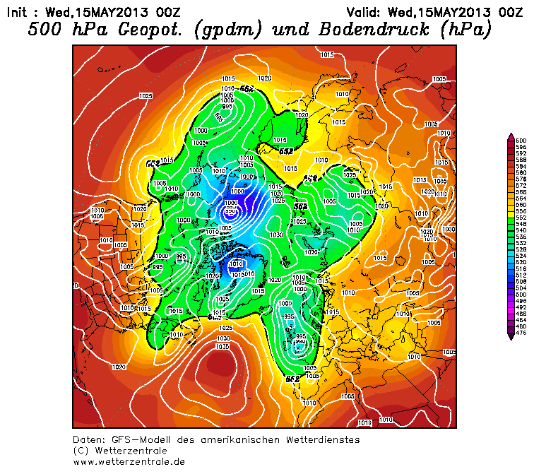
By the date of writing the system has been replaced by a high pressure system, predicted to persist for the next few days.
This low pressure system was not exceptional. Brummer et al, 2000, "A cyclone statistics for the Arctic based on European Centre re-analysis data." PDF, find that for the 1986 to 1991 period, summer (April to September) lows have typical range of 980 to 1020 hPa. The May 2003 low pressure system had its lowest pressure of below 990 on 25 and 26 May (GFS). So the low pressure was not exceptional, but was at the intense end of the spread of intensities for the 1986 to 1991 baseline.
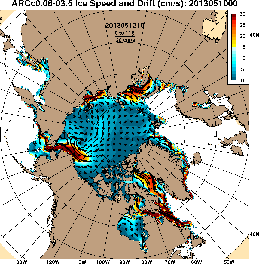
The effect of the winds within the low pressure on the ice is striking, as can be seen from this animated gif from HYCOM (US Navy), showing modelled sea ice drift.
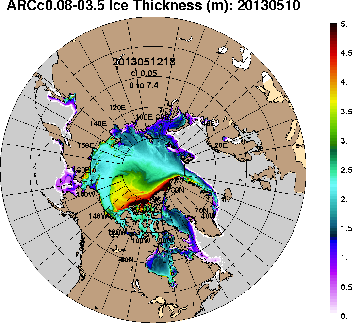
And the effect on thickness in the HYCOM model is even more stunning.
This thinning is caused by a massive drop in concentration, as also seen in HYCOM, 1 Jun 2013, which is projected to worsen over the coming week, 8 June 2013. However it should be visible by now in MODIS and AMSR-2. Here is a timeseries of AMSR-2 from University of Bremen, I've not included it as an image on the page due to its size (severely slowed page response), click and it will open in a new window. There is no localised region of low concentration, the concentration reduces over a large area of the pack. However if you click on that image to bring up a full size image you'll be able to see how the pack twists in an anticlockwise manner consistent with the wind direction.
MODIS gives a far better resolution, below is a blink comparison between MODIS for day 142 (22 May 2013) and day 152 (1 June 2013). Source; r04c04 of MODIS Arctic Mosaic.
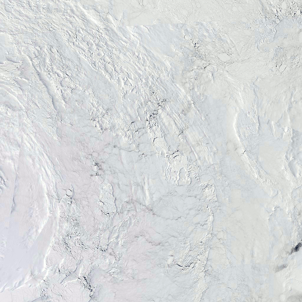
This shows the damage done to the pack, but is in the region where HYCOM shows concentration down to 60% and lower, and yet it does not show this.
So in reality we do not see the sort of opening of extremely thin ice due to extremely low concentration in HYCOM. Instead Bremen indicates a wider region of lowered concentration. What is going on here?
In my post on the Beaufort breakup of February 2013, link, I closed by observing that HYCOM showed a large opening of open water off Banks Island, which was not seen in reality (IR satellite images). I noted that this seemed to be because the modelled ice was stronger under tension than real sea ice. This is because the February breakup was driven by the ice being pulled clockwise by prevailing winds, so when the ice was put under tension along the Alaskan coast, this was relieved by a succession of parallel fissures opening. In the HYCOM model these fissures didn't open, so the net movement was revealed by a single area of open water (covered by thin new ice) rather than parallel fissures.
I think we have a similar situation in HYCOM during the May storm. This time the decline of concentration has been over a larger region than in HYCOM (as seen in Bremen). With HYCOM producing a centralised area of very low concentration due to the surrounding ice not forming the fragmentation seen in reality (MODIS/Bremen).
This also helps to cast light upon the driving factor behind the reduction of concentration and consequent thinning. The issue here is whether the reduction of concentration is due to movement of ice or melt where the ice is. Given the behaviour of HYCOM and the similarity of behaviour with the February breakup, it seems to me that it is net divergence of ice that is predominantly lowering concentration, not melt.
This divergence is over a very large area, as can be seen by a blink comparison over the period of the storm.

This is not to say there will not have been some melt. It has been suggested that Ekman transport will have bought deeper warmer water into contact with the ice. But whether Ekman transport has played any significant role remains an open question, the nearest Ice Tethered Profiler, ITP57, shows no indication of disturbance to the ocean column, but it is not in the region worst affected by the storm. Because I see the main driver as divergence, not melt, I do not expect a significant impact on overall volume when the PIOMAS figures for May come out later this week.
For me the issue is not the probably small role of melt in the thinning of the ice over the last week, it is the implications this might hold for later in the melt season. Whilst the extreme low concentration shown by HYCOM does not seem to be the case to me, this is effectively spread out over a wider area of fractured floes and reduced concentration. This storm has broken up floes introducing water channels and increasing the opportunities for lateral melt in the run up to the maximum of insolation later in June. This is a perfect opportunity for ice-albedo feedback to get to work more effectively than it may have without the May storm.
8 comments:
would an increase in ice channels decrease the surface water, potentially limiting melt-albedo feedback?
also it seems to me that at some time during the period the animation covers, almost all thick ice had a velocity along the top of greenland, towards being dumped down the the coast.
Would you be able to have a post on the different ice area/concentration/extent measures, as it seems that some ignore many small holes, others are biased, and perhaps the most useful (volume calculated from thickness) is the hardest to measure accurately and interpret correctly.
(capture "sufficiently longspti")
Andy,
"would an increase in ice channels decrease the surface water, potentially limiting melt-albedo feedback?"
Not sure I understand you here, but I'll try to answer anyway. :)
Normally melt proceeds from the edges of the pack, so lateral (horizontal) melting is limited by the available ice edge.
The pack isn't one mass of ice, as far back as I can recall it's always been a mass of fractured floes of ice, although this seems to be getting worse as the pack thins. However if there are enough broken floes with open water between them then this allows the open water to absorb sunlight and increase lateral melt.
If you look at the second to last image in the blog (blink comparison between MODIS for different days), you can see more areas of open water after the storm than before. For similar levels of insolation during each period the pack after the storm will exhibit stronger ice albedo feedback.
I'm a bit out of date with regards extent, it's been about two years since I followed it. But I will seriously consider such a post.
Forgot to add - the ice flowing down the east coast of Greenland floes into the Fram Strait, between Greenland and Iceland, and is melted there. This is normal, and yes it is a major source of loss of multi year ice.
Great post, Chris. I've quoted some of it in my latest article on the ASIB: New map on the block.
BTW, this is one of the reasons that I take the ACNFS forecast with a grain of salt. But to be fair, it was the 'hole' that was predicted (and your and others' discussion of it on the ASIF), that drew my attention to this event.
Following...
It seems to me andy's question was about ability to hold melt ponds.
I would suggest the ice floes are still pretty big even if the ice is more broken up.
How flexible is ice? Enough to curve down in the middle and up at the edges and is this effect significant for melt pond capture on large floes but not for small floes?
Neven,
I still think the model is very useful and will continue to use it. As with any model being aware of the caveats is part of using the data. Actually that applies to all data.
Crandles,
You're probably right, and I agree that the floes are still pretty big. At 250m per pixcel, even a 250m X 250m pond covering one pixcel is a decent size melt pond.
I don't think mechanical deformation is the issue with ponds. As I understand it's melt from the suface and resultant ice albedo feedback.
Chris, I never said it wasn't useful, just that I didn't trust it all that much.
Captcha: isoftme manner :-)
Post a Comment