Last year weather led to a pulse of increased volume being fed into the sea ice system, since then we have seen this pulse being severely reduced. Now much of the increased extent of older ice (multi-year ice or MYI) in the Central Arctic has been transported out into Beaufort and is currently making its way into Chukchi. What does this mean for the coming melt season?
As posted in my February 2014 Update, the volume pulse from the muted 2013 melt season has been severely reduced, I think that this was largely due to a negative Pacific North American (PNA) like atmospheric set up, more here. This can be seen best by considering the difference in regional volumes between 2014 and 2013 for January and February, as shown in this copy of a graph from my February post.
From this it can clearly be seen that the overall (All PIOMAS domain) and Arctic Ocean volume increase between 2013 and 2014 was substantially reduced by February.
However this is not all that has happened, over the winter the increased amount of older multi year ice (MYI) caused by greater ice survival in 2013 has seen a massive movement into the Beaufort Sea and onwards towards the Chukchi Sea.
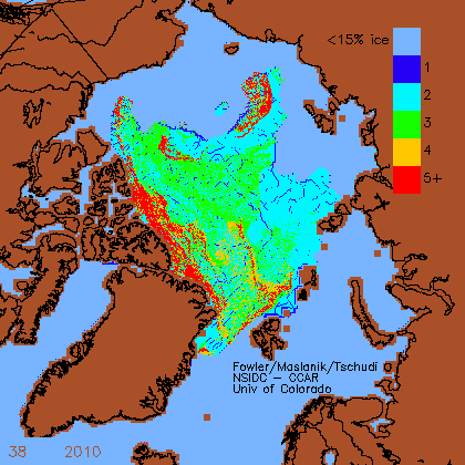
A similar event occurred over the winter of 2010, and was a significant player in the 2010 volume loss event as discussed here. The following animated gif uses images from the Drift Age Model (DAM) provided by Fowler/Maslanik/Tschudi, available at ftp://ccar.colorado.edu/pub/tschudi/iceage/gifs/ .
Starting from week 45 in 2009 it can be seen how there was a substantial movement of older (especially red +5yr old) ice into Beaufort and Chukchi, by week 35 of 2010 most of this had melted out, leaving a remnant mass off the coast of Siberia. However in doing to it kept a spur of dispersed but notably persistent ice in the same region, e.g. Bremen (between 150 and 180 degE).
Thus the extent and area for 2010 were unremarkable, while the volume loss of that year is an outlier in the context of the post 2000 interannual volume changes (2007 and 2010 were about -2 sigma). By week 38, when ages were incremented upwards to account for the end of the melt season, how little of that MYI survived is seen below.
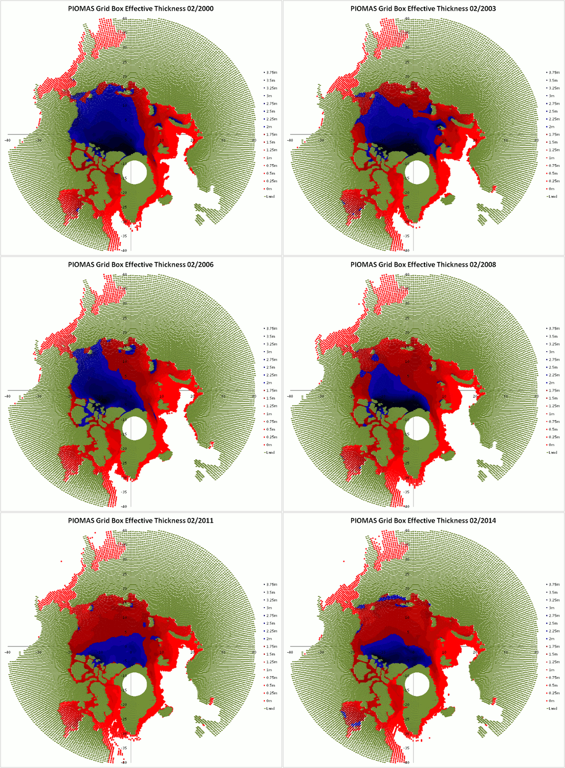
The effect of this loss of volume can be seen in the following animated gif showing ice thickness in February, whilst there is an overall thinning, both 2007 and 2010 show marked decreases in thickness.
This decrease of thickness is even more striking in the plots of PIOMAS thickness provided by the Polar Science Centre. Where 2010 ushers in a step break from the preceding years.
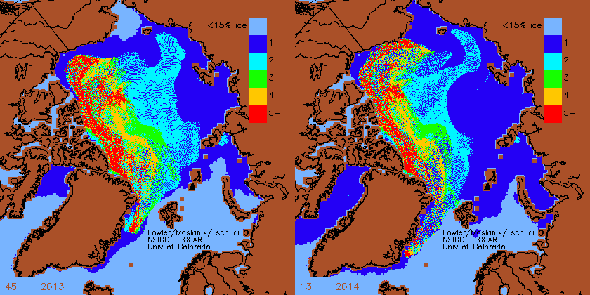
Now over the winter of 2013/14 a similar movement of MYI has happened into Beaufort and the eastern Chukchi Sea.
Comparing the most recent plot for 2014, week 13, with that for week 13 of 2010 shows that whilst the movement has not progressed as far (I don't think the Beaufort Gyre has been as vigorous as in 2010) the extent of ice seems to be much greater. As we move into the summer (it is only April now) more of this will be transported towards the East Siberian Sea.
This suggests to me that while this melt season will see probably a large volume loss as this older thicker ice is thinned and subjected to lateral melt, a total melt out in Beaufort, Chukchi, and possibly as far as the East Siberian Sea, is looking unlikely. I suspect we may see persistent low concentration ice in those regions by late summer. NSIDC seem to be of a similar mind, but don't consider the volume issue.


9 comments:
This supposedly "multiyear" ice is significantly less than 2 meters thick in April, based on the buoys. Are we really to believe it isn't going to melt?
In 2012 there was more ice on the Alaskan side of the Arctic than this year, and it simply didn't survive. I guess it's just too dependent on weather, which cannot be predicted this far in advance...
Nightvid - Whilst I have my own doubts about the thickness of the ice in the Beaufort Sea at the moment, I don't think your "significantly less than 2 meters" is entirely accurate.
The buoys don't tell us a whole lot about the distribution of thickness across the Beaufort. 2013F which is presumably now on 2nd year ice has so far increased in thickness to 1.66m. Not a terribly impressive number I agree. However 2013G, presumably on MYI, is now 2.64m thick, much as it was last September.
What about the Atlantic side though? The NPEO buoys will be up and running any day now, but there doesn't look to anything very substantial left between there and Svalbard.
Nightvid,
I can only second Jim's cautionary note - individual ice buoys don't tell us about regional thickness.
PIOMAS 2012 was of the order of 25cm thicker in February than this year in Beaufort. But the extent of MYI was far less:
ftp://ccar.colorado.edu/pub/tschudi/iceage/gifs/age2012_13.gif
What happened in 2010 was not a total failure to melt in the region between 150 and 180 degE in the Bremen plot I referenced. what we saw in MODIS was a mass of small floes by late summer, this was enough to hold extent up in 2010. That only takes over 15% ice - small floes in water.
I expect a similar pattern by the end of summer in the Alaskan sector of the Arctic. Of course weather conducive to melt could mean that doesn't happen.
Jim,
PIOMAS February shows little difference between February 2012 and 2014. I agree that loss in that sector could be substantial.
Most of that band of MYI that was going around the Gyre in 2010 was in the Beaufort and Chukchi Seas and just simply melted.
This year the thickness is lower than 2010 and a volume/thickness drop the size of 2010 would push us to a new minimum with less ice than even 2012. So if 2010 is your argument, shouldn't you predict a record low in 2014?
Also, since the volume drop trend over the last 10-15 yrs has been significantly positive, we're kind of "overdue" for a volume drop bigger than 2010. So I wouldn't be surprised if we smash 2012 by quite a lot, but of course it depends on the weather.
Nightvid,
I don't buy the 'overdue' argument. Both 2010 and 2007 happened for specific reasons/mechanisms, there is no reason to presume the system can become overdue for an occurrence of these mechanisms.
I think a new record volume drop is feasible, but I expect extent to be held higher in Beaufort and Chukchi. I don't expect that MYI to melt as easily as FYI would in the same location, but weather conducive to melt could mean a large volume and extent loss occurs.
The summer circulation in 2010 was highly unfavorable, more reminiscent of a dipole circulation with plenty of sunshine over the western arctic.
I guess if you expect a dipole summer, you could use 2010 as an analog.
Hi PHz13,
To a greater or lesser degree all the years 2007 to 2012 have shown a strong summer (JJA) dipole anomaly, except July 2010, the dipole being high SLP over the western Arctic and low SLP over the eastern Arctic.
This summer I expect a similar dipole anomaly. I view last year's reversal of the pattern as an anomaly.
Thanks for the reply. I'm not sure I agree with the dipole prediction, based on two major hurdles:
1) The QBO...while we've seen a wind reversal above 30hpa, westerlies are dominating below 50mb and should continue to do so through July-August. This, for many reasons, favors ridging over the NPAC Russia/Eurasia.
2) The final warming/wave-breaker/PV breakdown in the arctic stratosphere is taking longer than usual. Historically, this favors a stronger spring PV and a +NAO through July at least.
So, I guess we'll see where this goes. I look forward to it. :-)
Post a Comment