NOTE - the final part of this blog post has been changed as an error was found in my transformation from CT Area to NSIDC Extent.
The anomaly cliff is seen in plots of anomaly from the long term average, I use 1980 to 1999 as the long term average period in order to highlight recent changes in pack behaviour. The current situation compared with recent years is shown below.

Clearly 2014 is not exhibiting the sort of cliff seen most clearly in 2012, but also visible in 2005, 2007, 2010, 2011, or even 2013. Anomalies are calculated against the average area for each day, they are the difference between actual and average area for each day. So how the anomalies behave is critical to determining what may come in the near future. The changes between each day in CT Area during June for the average seasonal cycle over the period 1980 to 1999 are graphed below.

It can be seen that as the average cycle enters the second week in June the loss rate increases. This means that for 2014 to exhibit large losses of anomalies, the actual losses from day to day must exceed this growing rate of loss in the average seasonal cycle. In a year like 2012 the early June losses leading to the 'Cliff' are large, but they also start early during a period where average loss rate is relatively small, hence the precipitous drop in anomalies. That is not the case this year.
Up to 17 June 2014 weather conditions were not favourable for melt, as seen in the plot below sea level pressure (SLP) was high over much of the pack, but with a low pressure tendency over the pole - due to low pressure systems over the ice through early June. This set up brought cloudy cool conditions.
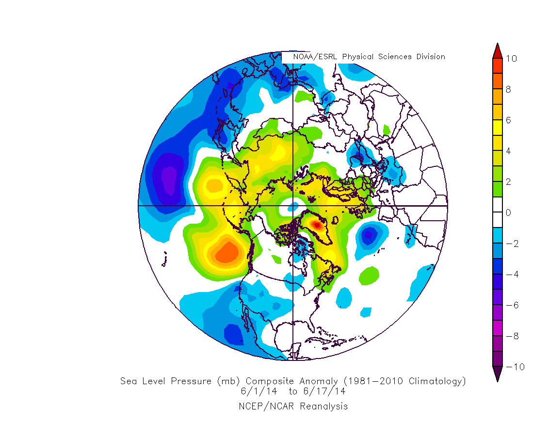
Very recently however the situation has changed, starting a set up more like the summer average for 2007 to 2012, conditions conducive to ice melt, with open skies allowing sunlight onto the pack, and occasional dipoles drawing warmer air in from outside the Arctic between regions of high and low pressure.

Switching to NSIDC Extent, the effect of this can clearly be seen, up until 18 June 2014 the losses from day to day were variable, from 18 June a continual pattern of loss sets in. In the 7 days since 18 June 2014 NSIDC Extent has declined (-0.773M km^2) more than in the 14 days preceding 17 June 2014 (-0.719M km^2).

The prediction method I used effectively last year depends on the low slope of late summer CT Area losses. The following graph shows the slope from the day on the X axis to minimum for 1979 to 2013 for NSIDC Extent and CT Area.

A property exhibited by CT Area, but not by NSIDC Extent is that the late summer losses show little trend from 20 June onwards. Using the data for 20 June I have calculated the average loss from 20 June to minimum in CT Area, this is 5.311M km^2 (std dev 0.192M km^2). Differences between hindcast and actual September minimae are then calculated to define the range of the prediction, this is then used to calculate hindcast prediction bounds, and a forecast for 2014. The following graph shows hindcast, forecast and bounds.

Last year in my prediction using a similar technique on 30 June I ended up narrowing my prediction to the lower half of the range, i.e. between the central estimate and the lower bound, dispensing with the central estimate to higher bound range altogether. I'm going to do the same thing this year, so my prediction for CT Area in 2014 would be 3.05M km^2 to 3.29M km^2. I'm going to round to a single figure after the decimal point, this makes my CT Area prediction for 2014:
3.0 to 3.3 million kmsq CT Area for the 2014 daily minimum.
In terms of past years this range includes 2008, 2010, crucially this excludes a re-run of 2013 or a new record beating the record year of 2012. However I don't rule out a CT Area daily minimum in 2014 of between, 3.0 and 2.9. I was tempted to lower the lower bound by 0.1 to account for this expectation, but I've decided to stick to the numbers calculated and leave my only judgement input as the selection of the lower range.
What does this mean with regards my June SIPN prediction? Before I go into that I should note that my original prediction had been based on numerical monthly averages of the daily NSIDC extent figures downloaded from this page, Whatever metric SIPN judge success or failure on, I will be assessing my SIPN prediction on the numeric monthly average of that daily data.
The equation NSIDCExtent = 1.8527 x CTArea^0.8298 is the power function regression between NSIDC monthly average September extent and CT Area daily minimum, it has an R2 of 0.96. A power function is chosen as it neatly brings the two indices to zero at the same time.
The following has been extensively edited due to a mistake in my original calculations, I hadn't updated the transformation equation to the one stated above in the last stage of calculation.
Using this equation I can transform my CT Area prediction into one in terms of NSIDC September average extent. I've also used the residuals from the fit over 2007 to 2013 to determine additional error due to the transformation. Basically just using the maximum and minimum residual between 2007 and 2013 and applying that as an offset to the figures calculated using the above equation. The resultant prediction for NSIDC Extent September monthly average is 4.61M km^2 to 4.98M km^2.
I had been considering what to do for the July SIPN prediction, and had thought that if nothing else occurred to me, my fallback could be simply taking the upper half of the June prediction range, a choice driven by the slow start to the season in June. That would have given me a range of 4.06M to 4.62M km^2.
So the two ranges for September sea ice extent do not agree at all. This causes a problem for me. However the 20 June CT Area prediction takes into account events in June, so I'm going to stick with that, accordingly my 20 June NSIDC Extent prediction for NSIDC September would be:
4.6 to 5.0 million kmsq for September 2014 sea ice extent.
I'm going to see what the end of June data from PIOMAS and other data shows before considering what I will submit to SIPN for July.
2 comments:
Very nice, Chris. Looking forward to your votes on the ASIF. :-)
Thanks Neven,
I'll be posting once I see June's PIOMAS data.
Post a Comment